What we do
Our team is committed to understand and to help you conceptualize your needs. We put at your disposal the full range of today’s geospatial technologies – remote sensing, GIS, geo-statistics and mobile survey devices – to design, create and deliver pragmatic and cost-effective solutions that best meet your requirements. We work for both the public and private sector.
Early stage support services
- Conceptualization of needs
- Analysis of technical, financial and organizational constraints
- Information strategy definition
- Project design
Consulting services related to geo-spatial technology
- Technical assistance, coordination and project management
- Support at all stages of the life-cycle of a GIS and/or Remote Sensing related project
- Capacity building and Training
- Design, writing and review of (Requests for) Project Proposals
Production of timely, relevant and accurate geo-information
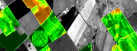
- Processing of remotely sensed imagery
- Data collection: Field survey, Mobile solutions, Digitizing, Data mining
- Map production
- Automated creation of Google Earth/Maps files with KMLizer™ , GE-Data’s special purpose KML data generator
- Web Mapping
Implementation of tailored and special purpose Geographic Information Systems (GIS)
- Analysis and definition of functional and technical requirements
- System design and architecture, modelling of spatial databases
- System development and implementation of spatial databases
Consultancy and engineering in geomatics and earth observation


